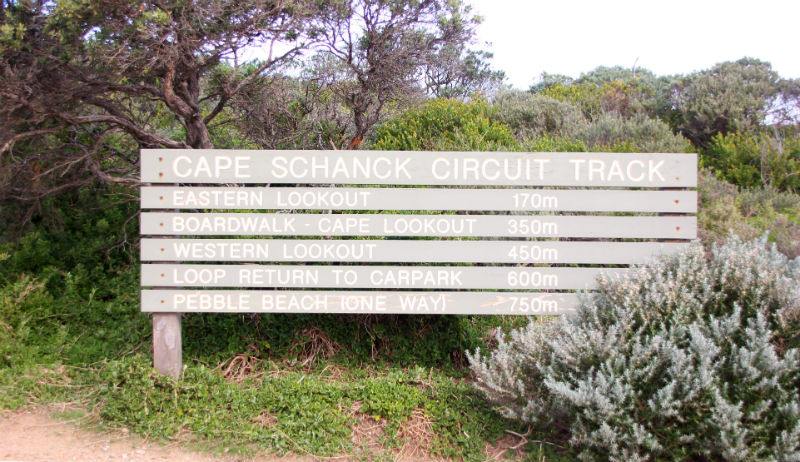
If you are looking to spent one to two hours on a leisurely hike with some beautiful views of the ocean, Cape Schanck is the place to go. It is situated on the southernmost tip of the Mornington Peninsula separating the turbulent waters of Bass Strait from the slightly calmer waters of Western Port.
Cape Schanck is better known for its iconic lighthouse and boardwalk. The Cape Schanck Lighthouse has served shipping since 1859. Constructed from dressed limestone and sandstone, the original mechanisms are still in place – which makes this lighthouse pretty unique!
Well-maintained, wooden boardwalk with views of the light house and Cape Schanck.
Positioned near the lighthouse, the boardwalk provides a scenic walk to the beach below with spectacular ocean views, dramatic volcanic features, unspoilt beaches and pleasant walking tracks. The waters are frosty blue in colour, and seals or dolphins can sometimes be spotted in the area. The stoney beach is scattered with rock pools while the tall, basalt cliffs lend a touch of mystery to the rugged backdrop.
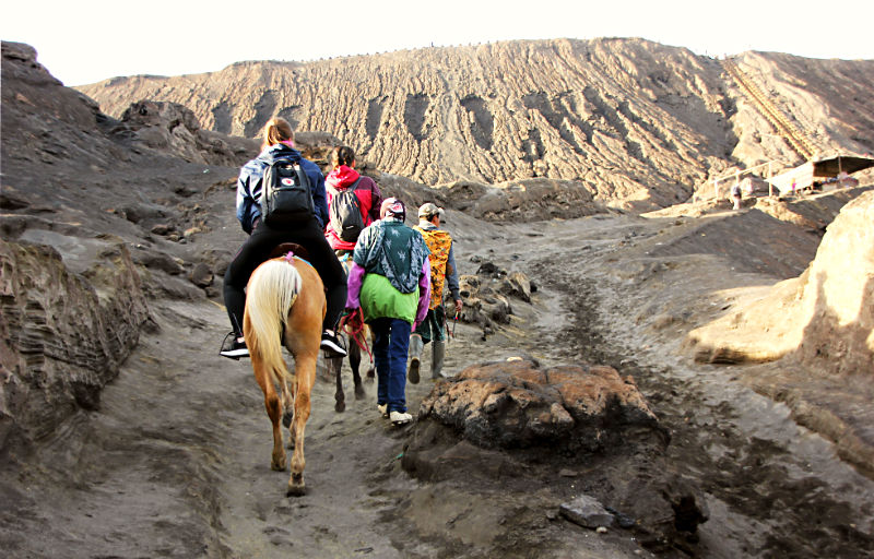
From the carpark, take the walking track to the left of the kiosk. This short circuit walk takes visitors to the start of the wooden staircase and boardwalk which descends to the beach and rock platform. There are several lookout points along the way that offer stunning views of geological formations created millions of years ago.
Cape Schanck is a great place to visit at any time of the year but remember to bring a jacket as it can get windy and chilly even with the sun shining overhead. The beach at the bottom of the boardwalk can get quite slippery with strong waves moving in and breaking across the rocky platform, so it’s best to keep out of harm’s way and not to stand too close to the water’s edge.
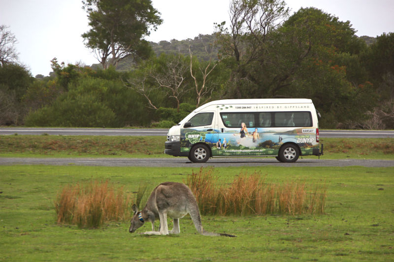
Wilsons Promontory, lying about 200km south-east of Melbourne, is one of Victoria’s best loved national parks in the Gippsland region. Fondly known as ‘The Prom’, this 50,000-hectare park offers sandy white beaches, rugged mountains, evergreen rainforests, numerous walking trails and rocky offshore islands. If you enjoy raw nature, stunning landscapes and wildlife, then The Prom should be in your must-visit list.
Over the years, I have been to Melbourne many times, but had never heard of Wilsons Promontory until my recent visit in June 2018. While flipping through the pages of a travel booklet on short Australian getaways, I came across Wilsons Promontory and immediately signed up for a day trip as I was due to leave Australia in two days’ time. At 7:00am on a Melbourne winter morning, I joined 8 others on a 3-hour journey from the City to Wilsons Promontory.
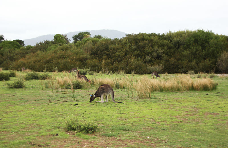
Our first stop was at The Prom Wildlife Walk, probably one of the best places to observe Australia’s native animals like kangaroos, wallabies, emus, echidnas and wombats. I was pretty excited to see so many kangaroos so soon into our arrival and took this as a positive sign that it was going to be a memorable day! Our driver and guide, Jeremy, led us on a short tour behind the wildlife viewing area where we got a glimpse of the native animals’ natural habitat.
This is wombat poo – cylindrical and flat at both ends.The emus only came out in the late afternoon.
Mount Bishop
We then headed towards Lilly Pilly Gully for what I thought was to be just a nature walk. This section of the trail cuts across Aussie bush, flowers and eucalyptus, allowing a glimpse into The Prom’s forested interior.
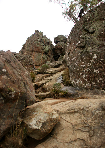
After walking for approximately 1.4 km, Jeremy told us to stop at the point where the trail forked into two. He asked who wanted to take the narrower and steeper left trail and continue for another 2.4km to the summit of Mount Bishop. The second option was to go along the more gentle Lilly Pilly Gully track that winds down a valley ending back at the carpark.
The hike to Mount Bishop.
Truth be told, I was not psychologically prepared to climb a mountain on that day. As it turned out, everyone except me voted to hike up to Mount Bishop. Jeremy started to brief me on my lone walk down the Lilly Pilly Gully track and told me to wait at the carpark for the others to return from Mount Bishop. The idea of doing the deserted Lilly Pilly Gully track did not appeal to me because I did not see any other hikers throughout the time we were using the trail. What if something unexpected happens and I cannot call for help? Did I mention that I am very prone to sprains? I even sprained my foot two weeks earlier at Hanging Rock! I changed my mind and decided to join the rest to Mount Bishop.
Mount Bishop is a 6.8 km, grade 3 return hike which takes about 2.5 hours to complete. Early sections are relatively easy-going, but the track becomes steeper and narrower, requiring you to step over granite rocks, logs and branches on the way. On reaching the top you need to continue a little further to a second set of boulders before the stunning views of The Prom’s coastline and offshore islands open up. This itself made the rock scramble to the top worth it.
Squeaky Beach
The next stop was to Squeaky Beach. If you’re wondering how this beach got its funny name, it’s because the even-sized silica grains of sand rub against each other, making a squeaking sound when you walk on the sand.
First view of Squeaky BeachThe sand is superfine, white and soft.
There is a medium-size stream running across at the beach’s entrance, so you need to walk in water or make a “bridge” from fallen branches to get across. I felt that I was agile enough to jump across and took a leap of faith to get across – just barely made it to the other side without getting my shoes wet!
Squeaky Beach is beautiful. The nearby rock formations create a range of rock pools and sandy passages worthy of exploration. The sea is a captivating shade of aqua, with strong waves breaking and spreading quickly across the rocks before receding back to sea.
While the rest made their way towards Tidal River, I opted to remain behind to take in the scenery for a bit longer.
The group on its way to Tidal River
Fifteen minutes later, the both of us got into the mini bus and drove to our meeting point at Tidal River carpark. There is only one general store, a Visitor Centre and a public toilet. By the time we got there, however, both the local store and Visitor Centre had already closed for the day.
While waiting for the rest to show up, I went to check out the surroundings…and what do you know? A wombat came right up my path and loitered around for quite some time.
I felt quite ecstatic to see this furry critter nibbling nonchalantly at the grass in front of me. It appeared totally unperturbed by my presence. The cute fellow even crossed the path and made its way right under the bench where our guide was sitting! By the time the others crossed Tidal River bridge and walked towards us, the wombat decided that it had had enough of humans clicking away with their mobile phones and disappeared into the bushes.
A seagull perched on a wooden bench at the Visitor Centre carpark
I had a great time at Wilsons Promontory and the day was over all too quickly. It’s really no wonder that many people return to The Prom year after year to enjoy what Nature has to offer.
Hanging Rock or Mount Diogenes lies near the townships of Woodend and Mount Macedon. This jagged outcrop, rising up from an open plain around 50 miles north-west of Melbourne, is the eroded remains of an extinct volcano. The rock is over 6 million years old, formed by an eruption of magma. Over time ice and wind shaped the unique rock pinnacles seen today.
This former volcano tells many tales about the history of the Macedon Ranges. It is very important both culturally and spiritually to the area’s 100 or so indigenous peoples. The site was used for sacred ceremonies and rituals. However, they avoided venturing to the rock’s summit, which they believed to be inhabited by evil spirits.
Perhaps Hanging Rock is more famously known as the main setting for Joan Lindsay’s 1967 best-selling book, “Picnic at Hanging Rock” and Peter Weir’s film of the same title.
This sci-fi, psychological thriller set in 1900 tells about a group of girls in an Australian boarding school who mysteriously vanish at Hanging Rock while on a Valentine’s Day picnic. Although the novel is entirely fictional, it is framed as though it is a true story, leaving audiences at the edge of their seats with many unanswered questions.
After their picnic lunch, four of the girls, Miranda, Edith, Irma and Marion, decide to climb and explore Hanging Rock with their teacher, Ms McCraw. In an inexplicable turn of events, the girls simply vanish – except for Edith who is hysterical and cannot explain what actually happened!
The boarding school and entire community is thrown into chaos and an intensive search for the girls ensues. One of the missing girls, Irma, is found at Hanging Rock, unconscious but unharmed. A series of terrible events follow with students pulling out from the boarding school, teachers quitting unexpectedly, a schoolgirl committing suicide and the headmistress, Mrs Appleyard killing herself by jumping off Hanging Rock. The community is not spared either and the story ends with the school and police station going up in flames.
The ending for the novel and film leaves audiences “hanging” in suspense as none of the missing girls are ever found. Fiction or folklore? We will never know!
Hanging Rock still commads an air of history, mystery and intrigue today. It remains a popular picnic spot and provides a backdrop for music concerts, markets and horse races.
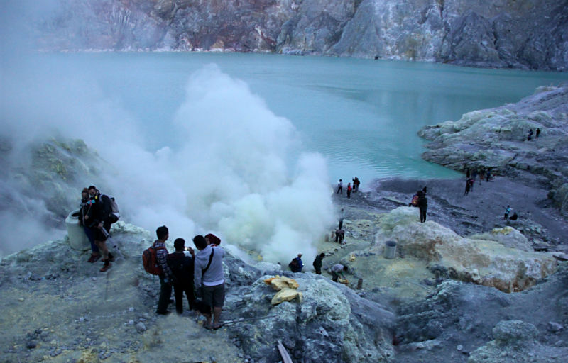
There is one volcano in East Java, whose reputation surpasses all others – Kawah Ijen (Ijen Crater) in East Java’s Banyuwangi Regency that is beautiful, mysterious and dangerous at the same time. Looking down from the caldera’s rim, you see the blue-green waters of a huge lake, with the smell of sulphur in the air.
Descend into the caldera before dawn and you might see the oxidation of sulphur gases emitting a blue flame.
Be around long enough for the sun to come out and the clouds to clear away, and watch the transformation of this lake into a cyan-coloured body of water with sulphur clouds pouring out of the pipes close by.
Climb To Ijen’s Rim
Our last day in East Java saw us outside the homestay entrance at 12:30am waiting for our driver and Ijen guide to take us to Paltuding base camp, the starting point of Ijen’s trail. We were to be accompanied by a very experienced Ijen guide, Anto, who was himself a sulphur miner for 7 years before calling it a day.
The asphalt road leading to the base camp was unlit, deserted and winding – barely wide enough for two vehicles to pass one another. The drive took about 40 minutes to arrive at Paltuding base camp which was jam-packed with hundreds of other climbers arriving in Jeeps. After purchasing our entrance tickets at IDR100,000 per person, we walked through an archway that marked the start of our climb.
The 2900-metre trail itself is well-worn, used daily by both hikers and Ijen’s famous sulphur miners. In the dark, the trail appeared pretty straight forward with no huge rocks to navigate. Unfortunately, I had underestimated the 17-degree incline across the 500-metre elevation and within 15 minutes of climbing, I was already out of breath. From then on, I had to take a short break every 8-12 minutes to recover.
Many sulphur miners were heading up in the same direction with their empty trolleys. Some were waiting on the sidelines, offering to take hikers to the summit on their trolleys (Ijen taxi) for between IDR600,000 – IDR800,000 one way. I didn’t take up the offer, of course. Stopping a while to catch my breath is one thing, but it would have been unthinkable to tell the folks back home that I went up Ijen volcano in a trolley!
It seemed like eternity to even reach the halfway point, where snacks and beverages are sold. Anto kept the momentum going by sharing his stories as a sulphur miner, greeting everyone in French, Spanish or Japanese, and inviting amused glances from others by singing at the top of his voice. Some of his miner friends even accompanied us for part of the way up with their empty trolleys in tow.
As we got higher, the tropical foliage gave way to barren rocks. The air became thick with sulphur fumes and some hikers started to put on their gas masks. We turned on our headlamps but visibility was still poor despite the direct beams from our headlamps.
The last 500 metres was less strenuous as the steep trail levelled off to a plateau. We had finally arrived at Ijen’s rim after 2.75 hours of climbing!
Descent into Hell
I didn’t take much notice of my surroundings until Anto gestured towards an enormous opening next to me. With barely any time to react, I found myself joining the others in making the 200-metre descent into the caldera.
It was so dark that the only way I could tell that there were people down below was from the lights of their headlamps, making the walls of this massive caldera look like it was lit by fireflies. The way down is narrow and treacherous so we had to take things slowly. There are handrails in some stretches of the descent but for the most part, you can only hold on to the boulders as you make your way down the winding, jagged steps.
We shared the steep path with at least 300 others, as well as with the sulphur miners. There is only enough space for one person at a time, so we had to follow the person directly in front of us. Whenever we encountered people coming from the opposite direction, someone had to step aside or lean against a boulder overlooking the abyss below to create enough space for the other person to pass. It was pretty scary.
Our eyes were fixed to the ground. There was no time for taking photos or other distractions. Each step was carefully calculated to make sure that we got safely around the huge boulders, and that we did not trip or get our feet caught between the rocks. When standing between hard rocks and a dark place, it is absolutely essential to have an experienced person to help you navigate through the cracks. Luckily for us, Anto lived up to his promise – “Don’t worry. You are coming to my home” and led us safely down to the heart of the caldera.
Three-quarters of the way down, we managed to spot the volcano’s blue fire flashing through the dense sulphur clouds. The wind was in our favour, blowing the fumes away from our direction so there was no need for a gas mask. We stood there watching the unusual sight of blue flames shooting out sporadically from the rugged walls of the caldera.
Ijen’s Sulphur Lake
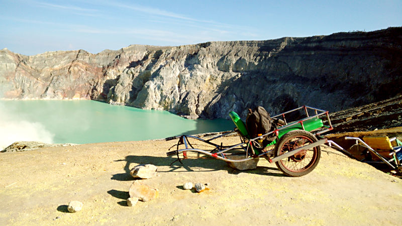
Ten minutes later, we continued down to the sulphur lake to have a closer look at the mining operations. Measuring 1 kilometre in diameter and 200 metres deep, this surreal-looking body of water is the largest acidic lake in the world.
Ijen’s lake appears dead blue before sunrise.
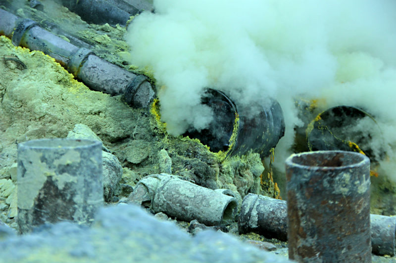
The sulphur pipes are close to the lake.The gases channelled through pipes condense into molten red sulphur. The molten sulphur then pools at the end of the pipes where it solidifies into a bright yellow mass upon cooling.The pipes appear to have been engineered by the miners in an effort to harness the sulphur around a small area for easier harvesting and collection.
Nearby volcanic rocks are stained yellow.
Sulphur Mining at Kawah Ijen – One Hell of a Job!
Kawah Ijen is home to one of the world’s most dangerous sulphur mining operations in the world.
The sulphur miners begin work shortly after midnight with a long hike up the volcano and work straight through until around 1:00pm when the clouds roll in making it impossible to get round the plateau.
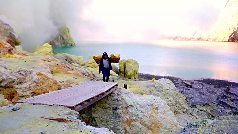
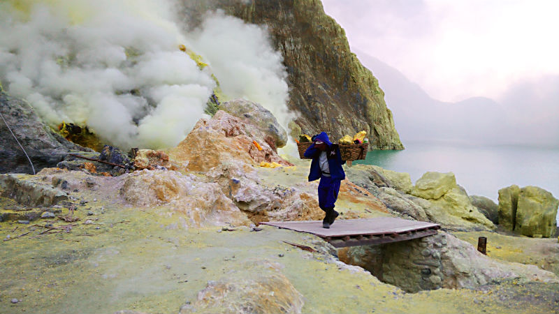
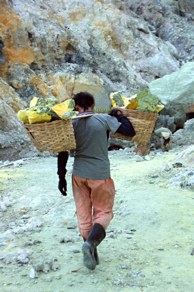
Miners walk up the flank of the mountain and then descend dangerous rocky paths down the steep walls of the caldera. Then, using steel bars, they chip away at the hardened yellow cake across the crater floor while being exposed to massive plumes of volcanic sulphur erupting out of the pipes. The sulphur ore is loaded into pairs of baskets attached at opposite ends of a long bar of wood. Each miner must make sure that the load is evenly balanced as he needs to haul his basket up the treacherous trail that leads to the top of the crater’s rim. Miners make two to three trips per day carrying up to 70 kg. to 100 kg. of sulphur each time. Payment is based on weight and the going rate for sulphur is about IDR12,000 for 10 kg. of sulphur.
The work is demanding and hazardous as it requires agility and strength to walk up and down the volcano’s steep slopes. Many miners suffer health problems from prolonged sulphur exposure. Deformed spines and bent legs are disturbingly common and the average life expectancy of a sulphur miner is around 50 years!
The changing colours of the sky at sunrise is reflected on the lake.The dangerously steep paths, the poisonous sulphur gases and occasional gas releases have killed many miners.Starting the long climb to the crater’s lip.Ijen’s sulphur lake at sunrise – beautiful but toxic.
A miner’s trolley at the volcano’s rim waiting to be loaded and wheeled to Paltuding base camp where they are transported to the refinery.
Descent to the Base Camp.
We were one of the last few to leave the acid lake and make the arduous climb back up to the crater’s lip.
Standing on top of the summit during daytime, we got the chance to have a better look at the surrounding landscape and terrain covered earlier on. All I can say is that it’s a good thing that it was too dark that morning to see how steep some of the gradients were!
Both hikers and miners share the same route to Ijen Crater.
It took us 1.5 hours to the base camp and we got to see some beautiful savanna views and rugged panoramas along the way.
The trek down Ijen’s rocky slopes took a toll on my legs. By the time we arrived back at the base camp my feet felt like they were on fire!
Do I have any regrets in climbing Ijen Crater? Not at all. It was one hell of a climb and the experience was frightening yet exhilarating. If there is a next time, I may even try out an “Ijen taxi” for part of the way so that the miners can earn some extra cash!
Must-Haves
Trekking shoes: A sturdy pair with good traction, preferably a size or two bigger so that they won’t pinch.
Gas mask: An essential item if you plan to descend into the crater. These can be rented at the base camp. If you go through a tour agency, gas masks are usually included in the package.
Headlamp: These are essential for night trekking to Kawah Ijen as there is no lighting along the track or down into the caldera. A headlamp is preferred to a torch light leaving your hands free for climbing purposes.
Drinking water: You can get easily dehydrated from climbing and the low temperatures. Water should be taken sparingly so that you don’t need to look for a toilet. After Paltuding base camp, there are no toilets unless you don’t mind visiting a “bush toilet”.
Trekking pole: Useful in navigating the steep slopes.
Experienced guide: This is one visit where you need a competent and experienced guide to lead you up and down safely.
Insurance. The rocky, steep terrain and reduced visibility especially at night increases risk levels.
Mount Bromo is not only Indonesia’s most iconic mountain but also the most hiked by travellers. At 2,329 m (7,641 ft) above sea level, it cannot even claim to be Java’s highest peak. That distinction belongs Mount Semeru (3,676 m or 12,060 ft) which stands imposingly in the background, like an older brother watching over his sibling.
So what is it about Bromo that makes people want to climb it? The adventure, the danger, the curiosity – these are some possible reasons. In any case, the stunning views from the summit are enough reason to go there!
The name Bromo is the Javanese pronunciation for Brahma, the Hindu god of creation. The Tenggerese inhabitants found here are one of the few significant Hindu communities left on the island of Java. The Tenggerese claim to be descendants of Roro Anteng and Joko Seger and the story goes like this:-
Majapahit Princess Roro Anteng and her husband Joko Seger fled marauding Islamic forces, ending up at Mount Bromo. They established a new kingdom, naming it Teng-ger using parts of their respective surnames.
The Kingdom of Tengger prospered and Hinduism flourished, but the couple was unable to produce any children. In desperation they prayed and meditated for many days on Bromo. Finally, the crater opened and the almighty god, Sang Hyang Widhi, promised that they would have many children provided that their last-born was sacrificed back to the volcano.
After producing 25 children, however, Roro and Joko could not bring themselves to sacrifice their last-born, Prince Kesuma. A dreadful eruption of Bromo followed and Prince Kesuma was swallowed up by the crater. Kesuma’s last words coming from inside the crater were that he had to be sacrificed so that the rest could stay alive. He asked that an annual offering ceremony be held on the 14th day of Kasada.
This unique and sacred Yadnya Kasada festival started by Kesuma’s brothers and sisters has been organised annually, and passed down the generations until today. It is held on the 14th day of the Kasada month (12th month) of the Tenggerese calendar. During this colourful festival, offerings of fruit, rice, vegetables, meat and even livestock are thrown into the crater.
At 3:30am, we were standing in the cool darkness at the base of Mount Bromo, ready for the climb. The whole place was pitch dark and eerily quiet. I had expected to see more climbers, but we were the only ones around at that time of the morning.
My headlamp proved to be ineffective in the vast blackness of my unfamiliar surroundings. I treaded carefully, afraid that any loose rock would cause me to slip and roll down. We were so focused on navigating our way up the craggy slopes that we didn’t notice anything else around us – until our guide told us to stop awhile and look upwards. It was a brilliant night with hundreds of diamonds across the sky!
After two hours, we finally reached the top, which was not too bad in my book, considering the number of photo and rest stops along the way. I found the hike to be quite challenging but the changing kaleidoscope sky, the silent silhouettes from faraway mountain ranges and stone structures, the floating clouds – made me forget my tiredness and aching feet.
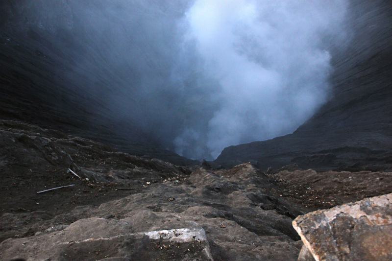
In order to arrive at the mouth of the caldera we had to climb a rather steep stairway of 253 steps.
At the top, I found myself at the rim of Mount Bromo looking straight down at the smoking caldera. There was a sense of triumph and elation that I had managed to make it this far – to be standing on the summit of one of the most active volcanoes in Java. (Bromo’s most recent eruption was in 2016.) I stared down at the bottomless black hole for some time, mesmerised by its sheer size and sulphur emerging from its fiery depths. Surprisingly, there was no smell of sulphur in the air – only a low howling sound from deep below calling me to come closer. I started to feel slightly dizzy and turned my attention to my surroundings.
Dangerous beauty.
Mount Bromo’s narrow ridge allows just enough space for only one person to pass at a time.
Some words of caution if you are reading this. The concrete pillars lining one side of the ridge are set too far apart to act as effective safety barriers. I must admit that my knees started to go a bit wobbly after standing at that narrow ridge for some time. An accidental slip would mean a dramatic entrance into either the smoking caldera or one-way ticket to the bottom of the stairway!
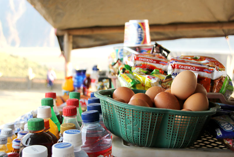
Looking at the Sea of Sand and Savanna from the volcano crater.Boiled eggs and coffee for breakfast under a makeshift tent set up at the base of the stairway.A Tenggerese man selling flowers for throwing into the crater.Horse rides to Mount Bromo are an alternative to hiking
After a simple breakfast at the base of the stairway, we made our way down the volcano and walked across the Sea of Sand where our Jeep was waiting.
We checked out of the homestay to embark on a 6-hour drive to Banyuwangi for our next adventure…but not before making a detour to Madakaripura Waterfall.
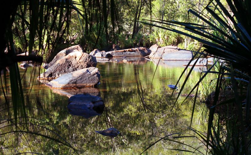
After the stint at Yellow Water to watch the sun set, we rushed to Garnamarr Camping Ground before the gates shut, or risk being locked out to sleep in the bush with crocs for company.
Garnamarr Camping Ground is the only campsite that allows access to Jim Jim Falls. It can take up to 250 people at any one time, and camping on the grounds is on a first-come-first-served basis. This campsite is not opened all year long – just during the dry season (May – October).
I must admit that I wasn’t expecting much from this camp ground in terms of public facilities. However, I was pleasantly surprised! Clean toilets, hot water showers, cubicles fitted with a dry bench area, available drinking water – what more could a tired visitor ask for? Security is also commendable. The camp gates are locked from 8.30 pm to 6.30 am daily.
On the way to Garnamarr, the bumpy gravel road caused a runaway stone to hit the back window of the 4WD, resulting in a tiny crack that gradually spread out to fill the entire frame. This incident forced us to make an unscheduled stop in No Man’s Land, in an effort to seal down the cracked glass with tape and bandage the injured window with a towel. Suddenly, the desire to sit closest to the rear door of the vehicle was gone! Everyone was hoping that the glass window would not crumble and give way.
Luckily, the cracked window remained intact right up to the end of the tour!
Inside my tent
It was great fun sitting round the campfire. There were a number of new things I tried out that evening. I learnt how to set up a tent on my own, and then had a go at the didgeridoo but failed to get a sound out of this ancient aboriginal wind instrument. Finally, I tried barbecued kangaroo meat and buffalo sausages with mashed potatoes and salad for the first time in my life. It was a simple but tasty meal.
As I settled down inside my tent for the night, I started to recollect the day’s activities – from the rocky waterfalls, massive gorges, gushing creeks, thriving billabongs, unique wildlife and diverse forests to gazing up at the twinkling silver stars peeping through my tent – what a precious gift to have the chance of experiencing those rare moments in the outback.
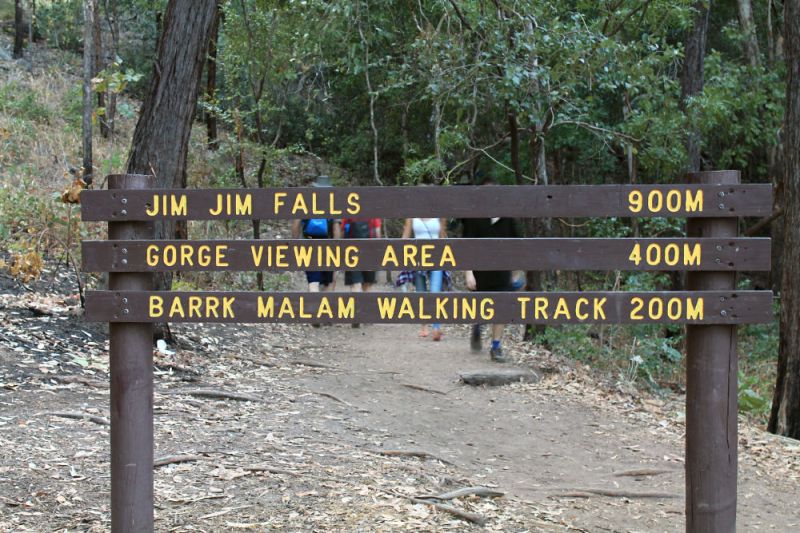
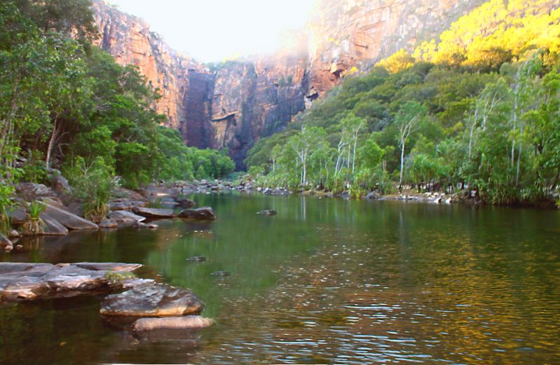
Jim Jim Falls
The road from Garnamarr Camping Ground to Jim Jim Falls is only suitable for high clearance four-wheeled vehicles. The track was uneven with deep ruts, gravel and sandy patches, creek crossings and thick muddy soil. Sitting inside the 4WD was like getting a strong massage. The ride was so rough that we were falling all over each other – forwards and sideways –especially when navigating the tight corners!
It is a 2 km round hike from the carpark to Jim Jim Falls The Jim Jim track is basically divided into three levels of difficulty. The first 100 metres or so is fairly easy, with the second part requiring scrambling over rocks, and the last part entailing a steep and slippery climb up the escarpment. What got me thinking twice about making it all the way to the waterfalls was our guide saying that accidents were quite a frequent occurrence during the last part of the hike, with some victims having to be air-lifted out of the area!
Crocodile trap seen along the creek.
I managed to breeze through the first part of the track and was even walking in front of the rest. However, as I hiked further in, the trail became more and more challenging. Soon, I found myself scrambling over jagged rocks and sandy boulders, trying to keep my balance and not slip between the rocks.
Still waters run deep and crocs lurk underneath
The first few metres of the track to Jim Jim Falls.
Rock scrambling for most of the 2 km hike to the waterfalls.
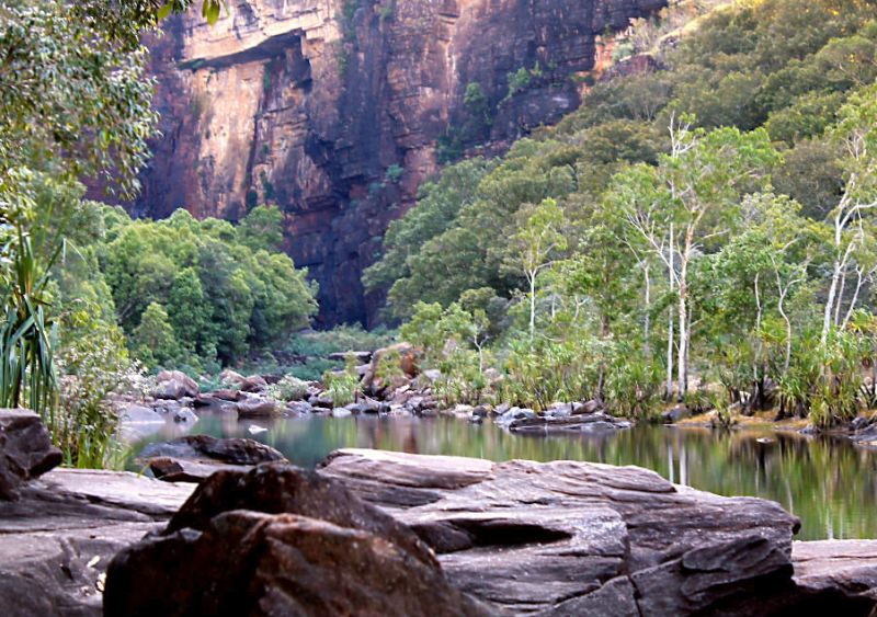
The hike took us past the Gorge Viewing Area where we got our first view of Jim Jim Falls. I could already see Jim Jim’s rocky escarpment in the distance. After this viewing area, the rocky track enters its third level of difficulty. At the thought of the struggle that lay ahead, I decided to remain at the viewing area and not proceed to the waterfalls.
First view of Jim Jim Falls from the Gorge View Area.
So while the rest proceeded with their hike, I stayed behind to catch my breath and enjoy the view. The place looked so serene that it was rather difficult to imagine that there is always the real danger of crocodiles waiting for their prey- under water and on land. While clicking away at my surroundings, I had to be extra vigilant that the world’s oldest reptile was not going to jump out of the calm water or appear from behind the rocks, and have me for its meal!
One of my biggest regrets about this trip is that I didn’t do enough reading about how fast crocodiles move on land. If I had, I would not have had to worry about what to do if a crocodile DID appear from behind the rocks, or wonder if I could scramble fast enough to outpace the reptile. This is what happens when you watch too many Sci-Fi movies about mutant super crocodiles that can chase you across the forest at 50 km an hour!
My decision to stay behind at the Gorge View Area was the right one. I felt good to have made it this far, and relieved that my limbs and camera were intact. After all, I was already at Jim Jim Falls – standing on the very ground that becomes a river bed during the rainy season. I scanned the raw landscape, grateful to have a few quiet moments to myself instead of feeling rushed and stressed out.
If you’re not too fussy about sleeping and want to see as much as possible within a short time, travelling in a 4WD is a great way to see Kakadu National Park. Entry to Kakadu National Park is AUD25.00 per person, valid for 14 days. Those under 16 years of age and Northern Territory Residents are exempt.
Would I do it again? Absolutely, without a doubt! There is still so much to learn, see and do. Getting a taste of Australia’s remote and wild outback – now that is really something to remember!
“It is good to have an end to journey toward; but it is the journey that matters, in the end.” ― Ernest Hemingway
After enjoying a short timeout at South Alligator River, we headed south for Barramundi Gorge or Maguk. The turn off is about 50 km from the southern entrance to Kakadu National Park and Maguk is another 12 km from that intersection. This unsealed track to Maguk is only suitable for 4WD vehicles. Once at Maguk’s carpark, you need to make a 2 kilometre round hike to view the spectacular swimming holes on top of the gorge as well as Maguk waterfall and plunge pool below.
The narrow trail inside the bush led us into a dense tropical forest with lush vegetation. The whole area was tranquil except for the sounds coming from rustling leaves and inhabitants of the bush. About 30 metres into the trail, we came to a boardwalk and I was secretly glad because I could now pay attention to the flora around me instead of trying to dodge the muddy ground. Further into the bush where the track crossed a small creek, a bridge had been built so that we didn’t have to get our shoes all dirty. Hmm.So thoughtful. I can live with this.
By and by, we came to a pristine jade-coloured pool. The water was so clear that I could spot small fish swimming around the water’s edge. However, none of us was tempted to venture too close to the water or stay there for too long for fear of crocodiles lurking underneath. Maguk has plenty of estuarine crocodiles. However, crocodiles safety measures have been put in place such that any saltie found moving upstream towards the gorge is relocated immediately.
When we came to an intersection where the trail branched out, our guide, Tom, said that it would be better to get the difficult part over and done with. So instead of hiking to Maguk Waterfall, we made the climb up the gorge to where the swimming holes were found. The further up we went, the more difficult the walk became. The path was uneven and slippery with stones. We had to navigate over huge rocks to make our way up. The hot sun was on us most of the time and I even experienced occasional flies buzzing above my head and getting into my nose! Some portions of the narrow track wound round the edge of the cliff overlooking the gorge below. The view was awesome – even humbling but pretty scary!
However, for every rock we scaled, the scenery became more and more breathtaking.
The rocky trail bordering the edge of the gorge.You might need to inch your way sideways or risk slipping over the side of the cliff.
Finally, we reached the top and the landscape opened up to a picturesque swimming hole. The place was surrounded by steep vertical sandstone cliffs, with ledges at different heights for diving.
After spending one hour at the swimming holes, we made our way down to Maguk Waterfall. I had thought that the walk to the waterfall would have been easier than the climb up the rock pools. However, the hike there had its own set of challenges. We had to step on rocks protruding above the gushing creek and criss-cross our way to the other side. No boardwalks or bridges here! You just eyeball a dry rock, muster enough courage and step on it. One wrong footing and you either get your feet very wet, or worse still, slip into the water! The two photos below show the scenery at the backwater end of the creek. They look nothing like the swift-flowing water and cascades that we had to cross!
After reaching the other side unscathed, we walked into some bushes and were rewarded with the sight of a lovely natural pool surrounded by red cliffs, with Maguk Waterfall completing the perfect backdrop. Maguk Waterfall is special in that it flows all year round, regardless of the season.
The cave to the right of Maguk Waterfall used to be a rock tunnel that led to the top of the falls. It is now closed to the daring and the brave.
While everyone else was enjoying a refreshing swim in the pool, a curious goanna appeared from behind the rocks and made its way towards me. It crept closer and closer until it was right in front of me, extending its long tongue to lick my shoes! After some hesitation, it turned and made its way to the rock I was sitting on, and sportingly remained still for me to take some close-up shots. Then, like a true gentleman, it let me have back my rocky seat and made its way slowly back into the bushes.
Soon enough, it was time to hurry back to the carpark and drive north to catch the sunset at Yellow Water. I must admit that the walk back across the creek was less stressful for me than the walk there. Perhaps I had become used to the idea of taking more risks. After I had gained a proper footing in the middle of the creek, I looked up at my surroundings for the last time. At that moment, I felt a surge of contentment on having found my balance with Mother Nature.
Last weekend, my friend, H, called to find out if I was interested to go to Mount Pulai again. For those who read my post about my first hike there last year, you would know that I suffered from terrible muscle cramps for both legs while three-quarters of the way to the summit. Since then, I have become wary of long, uphill walks. A few weeks after, I managed to sprain my ankle at Sungai Rengit and had to be home bound for a couple of weeks. It appears like I am prone to mishaps whenever I go on a day trip, and my poor legs at the receiving end! So you can understand my hesitation about revisiting Mount Pulai. However, I was given the reassurance that we could take our time, with no undue pressure to hike all 5 kilometres to the peak!
This time, I was better prepared. First, I decided to go light – no telephoto, wide-angled and macro lenses. I only brought my standard 18-55mm lens. Admittedly, my mind was plagued by a number of “What ifs”. What if I want to get a shot of a bird, or giant spider from a distance? What if I want a close-up of a flower or insect? However, sensibility prevailed in the end. When the pain extends all the way from the legs to the hips rendering you temporarily paralysed, the last thing you want to do is to take a picture of the pretty butterfly that’s landed on the rock next to you!
I also made sure that I ate something before leaving home instead of packing sandwiches like the first time. When you are inching your way downhill, hoping against hope that the next corner is going to get you out of the park, the thought deviating from the road and heading for the waterfall to eat sandwiches just makes me want to throw up!
Just to be doubly sure, I massaged both my legs with Tiger Balm cream and gulped down a muscle relaxant before leaving the house.
So at 6:15am on a Sunday morning, with the moon still in sight, we set off for Mount Pulai – my second visit to this recreational rainforest.
Even at that very early hour, all the car parks were full. Everyday of the week, come rain or shine, there are people here. The waterfall and the road to the peak attracts nearby residents to take a dip in the water or enjoy a good walk. Mount Pulai also attracts a fair number of Singaporeans, especially during weekends. The good thing about Mount Pulai is that while there are many visitors here, there is still enough space for everyone to enjoy the natural surroundings without getting in each other’s way.
This morning hike turned out to be enjoyable. Walking light had a lot to do with it, and also not fooling myself into thinking that I still possess the energy of a 20-year old who can make it all the way up the 5 kilometre road in under 2 hours! I got to take photographs, smell my green surroundings and tune in to the shrill cicada calls coming from the forest.
On our way down, we saw three white gibbons swinging from tree to tree. At road level, some dog owners were trying to get their pets to stand up. The dogs were flat out on the road, refusing to budge despite their owners’ coaxing! One or two just decided to pick up and carry their dogs for the rest of the way!
We were down at the park’s entrance by 9:45am! Declaring it a successful morning, we headed towards the nearest town for breakfast!