Ijen Crater: Hauntingly Blue, Beautifully Toxic

There is one volcano in East Java, whose reputation surpasses all others – Kawah Ijen (Ijen Crater) in East Java’s Banyuwangi Regency that is beautiful, mysterious and dangerous at the same time. Looking down from the caldera’s rim, you see the blue-green waters of a huge lake, with the smell of sulphur in the air.

Descend into the caldera before dawn and you might see the oxidation of sulphur gases emitting a blue flame.

Be around long enough for the sun to come out and the clouds to clear away, and watch the transformation of this lake into a cyan-coloured body of water with sulphur clouds pouring out of the pipes close by.

Climb To Ijen’s Rim

Our last day in East Java saw us outside the homestay entrance at 12:30am waiting for our driver and Ijen guide to take us to Paltuding base camp, the starting point of Ijen’s trail. We were to be accompanied by a very experienced Ijen guide, Anto, who was himself  a sulphur miner for 7 years before calling it a day.

The asphalt road leading to the base camp was unlit, deserted and winding – barely wide enough for two vehicles to pass one another. The drive took about 40 minutes to arrive at Paltuding base camp which was jam-packed with hundreds of other climbers arriving in Jeeps. After purchasing our entrance tickets at IDR100,000 per person, we walked through an archway that marked the start of our climb.

The 2900-metre trail itself is well-worn, used daily by both hikers and Ijen’s famous sulphur miners. In the dark, the trail appeared pretty straight forward with no huge rocks to navigate. Unfortunately, I had underestimated the 17-degree incline across the 500-metre elevation and within 15 minutes of climbing, I was already out of breath. From then on, I had to take a short break every 8-12 minutes to recover.

Many sulphur miners were heading up in the same direction with their empty trolleys. Some were waiting on the sidelines, offering to take hikers to the summit on their trolleys (Ijen taxi) for between IDR600,000 – IDR800,000 one way. I didn’t take up the offer, of course. Stopping a while to catch my breath is one thing, but it would have been unthinkable to tell the folks back home that I went up Ijen volcano in a trolley!

It seemed like eternity to even reach the halfway point, where snacks and beverages are sold. Anto kept the momentum going by sharing his stories as a sulphur miner, greeting everyone in French, Spanish or Japanese, and inviting amused glances from others by singing at the top of his voice. Some of his miner friends even accompanied us for part of the way up with their empty trolleys in tow.

As we got higher, the tropical foliage gave way to barren rocks. The air became thick with sulphur fumes and some hikers started to put on their gas masks. We turned on our headlamps but visibility was still poor despite the direct beams from our headlamps.

The last 500 metres was less strenuous as the steep trail levelled off to a plateau. We had finally arrived at Ijen’s rim after 2.75 hours of climbing!

Descent into Hell

I didn’t take much notice of my surroundings until Anto gestured towards an enormous opening next to me. With barely any time to react, I found myself joining the others in making the 200-metre descent into the caldera.

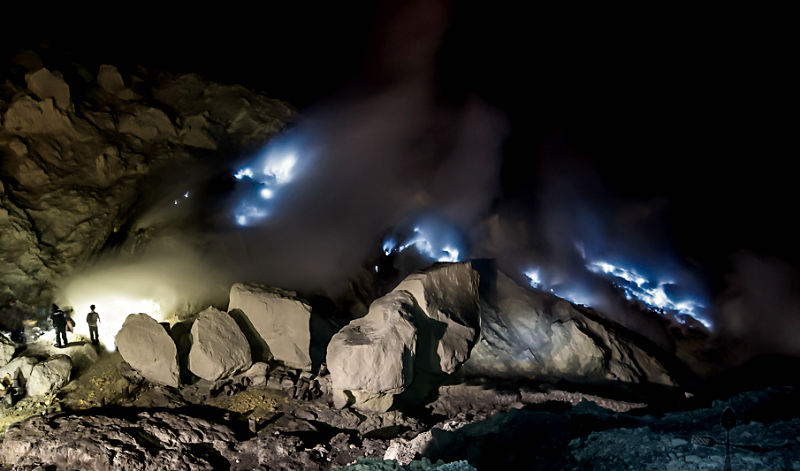
It was so dark that the only way I could tell that there were people down below was from the lights of their headlamps, making the walls of this massive caldera look like it was lit by fireflies. The way down is narrow and treacherous so we had to take things slowly. There are handrails in some stretches of the descent but for the most part, you can only hold on to the boulders as you make your way down the winding, jagged steps.

We shared the steep path with at least 300 others, as well as with the sulphur miners. There is only enough space for one person at a time, so we had to follow the person directly in front of us. Whenever we encountered people coming from the opposite direction, someone had to step aside or lean against a boulder overlooking the abyss below to create enough space for the other person to pass. It was pretty scary.

Our eyes were fixed to the ground. There was no time for taking photos or other distractions. Each step was carefully calculated to make sure that we got safely around the huge boulders, and that we did not trip or get our feet caught between the rocks. When standing between hard rocks and a dark place, it is absolutely essential to have an experienced person to help you navigate through the cracks. Luckily for us, Anto lived up to his promise – “Don’t worry. You are coming to my home” and led us safely down to the heart of the caldera.

Three-quarters of the way down, we managed to spot the volcano’s blue fire flashing through the dense sulphur clouds. The wind was in our favour, blowing the fumes away from our direction so there was no need for a gas mask. We stood there watching the unusual sight of blue flames shooting out sporadically from the rugged walls of the caldera.

Ijen’s Sulphur Lake

Ten minutes later, we continued down to the sulphur lake to have a closer look at the mining operations. Measuring 1 kilometre in diameter and 200 metres deep, this surreal-looking body of water is the largest acidic lake in the world.

IMG_4844a
Ijen’s lake appears dead blue before sunrise.

The sulphur pipes are close to the lake.
The gases channelled through pipes condense into molten red sulphur. The molten sulphur then pools at the end of the pipes where it solidifies into a bright yellow mass upon cooling.
IMG_4922a
The pipes appear to have been engineered by the miners in an effort to harness the sulphur around a small area for easier harvesting and collection.

Nearby volcanic rocks are stained yellow.

Sulphur Mining at Kawah Ijen – One Hell of a Job!

Kawah Ijen is home to one of the world’s most dangerous sulphur mining operations in the world.

The sulphur miners begin work shortly after midnight with a long hike up the volcano and work straight through until around 1:00pm when the clouds roll in making it impossible to get round the plateau.

Miners walk up the flank of the mountain and then descend dangerous rocky paths down the steep walls of the caldera. Then, using steel bars, they chip away at the hardened yellow cake across the crater floor while being exposed to massive plumes of volcanic sulphur erupting out of the pipes. The sulphur ore is loaded into pairs of baskets attached at opposite ends of a long bar of wood. Each miner must make sure that the load is evenly balanced as he needs to haul his basket up the treacherous trail that leads to the top of the crater’s rim. Miners make two to three trips per day carrying up to 70 kg. to 100 kg. of sulphur each time. Payment is based on weight and the going rate for sulphur is about IDR12,000 for 10 kg. of sulphur.

The work is demanding and hazardous as it requires agility and strength to walk up and down the volcano’s steep slopes. Many miners suffer health problems from prolonged sulphur exposure. Deformed spines and bent legs are disturbingly common and the average life expectancy of a sulphur miner is around 50 years!

IMG20171021060524a
The changing colours of the sky at sunrise is reflected on the lake.
IMG20171021060009a
The dangerously steep paths, the poisonous sulphur gases and occasional gas releases have killed many miners.
Starting the long climb to the crater’s lip.
Ijen’s sulphur lake at sunrise – beautiful but toxic.

IMG20171021065800a
A miner’s trolley at the volcano’s rim waiting to be loaded and wheeled to Paltuding base camp where they are transported to the refinery.

Descent to the Base Camp.

We were one of the last few to leave the acid lake and make the arduous climb back up to the crater’s lip.

Standing on top of the summit during daytime, we got the chance to have a better look at the surrounding landscape and terrain covered earlier on. All I can say is that it’s a good thing that it was too dark that morning to see how steep some of the gradients were!

Both hikers and miners share the same route to Ijen Crater.

It took us 1.5 hours to the base camp and we got to see some beautiful savanna views and rugged panoramas along the way.

The trek down Ijen’s rocky slopes took a toll on my legs. By the time we arrived back at the base camp my feet felt like they were on fire!

Do I have any regrets in climbing Ijen Crater? Not at all. It was one hell of a climb and the experience was frightening yet exhilarating. If there is a next time, I may even try out an “Ijen taxi” for part of the way so that the miners can earn some extra cash!

Must-Haves

Trekking shoes: A sturdy pair with good traction, preferably a size or two bigger so that they won’t pinch.

Gas mask: An essential item if you plan to descend into the crater. These can be rented at the base camp. If you go through a tour agency, gas masks are usually included in the package.

Headlamp: These are essential for night trekking to Kawah Ijen as there is no lighting along the track or down into the caldera. A headlamp is preferred to a torch light leaving your hands free for climbing purposes.

Drinking water: You can get easily dehydrated from climbing and the low temperatures. Water should be taken sparingly so that you don’t need to look for a toilet. After Paltuding base camp, there are no toilets unless you don’t mind visiting a “bush toilet”.

Trekking pole: Useful in navigating the steep slopes.

Experienced guide: This is one visit where you need a competent and experienced guide to  lead you up and down safely.

Insurance. The rocky, steep terrain and reduced visibility especially at night increases risk levels.

East Java’s Hidden Masterpiece: Madakaripura Waterfall

On the way down from Bromo, we made a stop at Madakaripura Waterfall, which lies at the end of a secluded valley in the foothills of the Tengger range. The tallest waterfall in Java and second tallest waterfall in Indonesia, Madakaripura Waterfall is the product of seven waterfalls. The locals consider this waterfall sacred since its waters are believed to pour blessings on those who walk underneath it.

On arriving at the carpark, we went into a wooden hut and tucked into a simple meal of nasi goreng while our Guide went to make arrangements for a local guide to take us to the Waterfall. In the past, visitors could just pay the entrance fee and explore the place on their own but now, it is mandatory for every visitor to engage the services of a local guide to accompany them.

We each got on an ojek and rode for 4 kilometres before arriving at an archway where tickets were being sold. I thought that we had finally arrived at the Waterfall but it turned out that the arch marked the starting point of a 2-kilometre hike to Madakaripura Waterfall! We kept walking on a gravel track until we arrived at a gate with a statue of Gajah Mada in meditation.

A statue of Gajah Mada at the entrance of Madakaripura Waterfall

Madakaripura translates to “the last residence of Gajah Mada“. This waterfall is believed to be the final meditation place of military Commander-in-Chief and Prime Minister, Gajah Mada, of the Majapahit kingdom in East Java that thrived between 1293AD to 1500AD. It is believed that the source of his overwhelming power and abilities came from within the cave of Madakaripura Waterfall, where Gajah Mada frequently went to meditate. According to legend, the 60-year-old prime minister vanished spiritually and physically (moksa) while meditating. His body has never been found.

We followed a concrete path that led into the dense forest, cutting across tall cliffs and streams. The all-round lush, green landscape, giant palms swaying in the wind and soothing sound of rapids moving downstream gave the whole surrounds a peaceful, tranquil feel. It is not difficult to imagine why Gajah Mada came here whenever he wanted some alone time.

The deeper in we trekked, the more beautiful the views became. Just outside the entrance to a huge cave, two local men offered to sell ponchos, umbrellas and plastic bags to us. We declined politely since we already brought along our own raincoats, sandals and a change of clothing.

Once we stepped inside the cave, it was like being in a different world altogether. I could see sheets of water flowing down the rock walls, forming puddles and rivulets on the cavern floor. The walls were covered with moss and crawling greens. The thundering sound of falling water above our heads, water seeping through the cave’s roof and hitting us with mist and spray – it was both amazing and surreal.

While we did our best to stay dry, it soon became apparent that we would have to walk in water to move forward. Fortunately, our local guide showed the way to safely wade across the sharp and slippery underwater rocks. The water reached up to the knees for most part and I was glad to be wearing sandals instead of flip flops, as their grip minimised the possibility of getting cut.

Things brightened up when we reached the other end of the cavern. We could see water cascading down a steep, semi-circular opening. In order to get to the plunge pool in the main chamber, we had to climb, squeeze and inch our way between the rocks…but the risk and effort was well worth it. Once we made it past the boulders into the tabular chamber, we were rewarded with a spectacular and breathtaking view of Madakaripura Waterfall!

The sunlight pouring from the opening above onto the wet, green moss gives the plunge pool its green colour.

This huge cave behind Mada Waterfall is believed to be the meditation site where Gajah Mada was last seen.
The emerald-green water from the plunge pool was crystal clear but icy cold.

The images here do not do this Waterfall any justice. It was impossible to capture the scenery in its entirety, given the limited space and towering walls encircling this 200-metre drop cascade. You’ve got to be there in person to appreciate its awesomeness.

An hour later, it was time to get out of the forest and make our way back to the carpark.

What a special morning it turned out to be! Coming to this majestic Waterfall as our last stop was a fitting way to wrap up a most memorable visit to the Bromo-Tengger-Semeru National Park.

Sunrise Hike to Mt. Bromo

Mount Bromo is not only Indonesia’s most iconic mountain but also the most hiked by travellers. At 2,329 m (7,641 ft) above sea level, it cannot even claim to be Java’s highest peak. That distinction belongs Mount Semeru (3,676 m or 12,060 ft) which stands imposingly in the background, like an older  brother watching over his sibling. 

So what is it about Bromo that makes people want to climb it? The adventure, the danger, the curiosity – these are some possible reasons. In any case, the stunning views from the summit are enough reason to go there!

The name Bromo is the Javanese pronunciation for Brahma, the Hindu god of creation. The Tenggerese inhabitants found here are one of the few significant Hindu communities left on the island of Java. The Tenggerese claim to be descendants of Roro Anteng and Joko Seger and the story goes like this:- 

Majapahit Princess Roro Anteng and her husband Joko Seger fled marauding Islamic forces, ending up at Mount Bromo. They established a new kingdom, naming it Teng-ger using parts of their respective surnames.

The Kingdom of Tengger prospered and Hinduism flourished, but the couple was unable to produce any children. In desperation they prayed and meditated for many days on Bromo. Finally, the crater opened and the almighty god, Sang Hyang Widhi, promised that they would have many children provided that their last-born was sacrificed back to the volcano. 

After producing 25 children, however, Roro and Joko could not bring themselves to sacrifice their last-born, Prince Kesuma. A dreadful eruption of Bromo followed and Prince Kesuma was swallowed up by the crater. Kesuma’s last words coming from inside the crater were that he had to be sacrificed so that the rest could stay alive. He asked that an annual offering ceremony be held on the 14th day of Kasada. 

This unique and sacred Yadnya Kasada festival started by Kesuma’s brothers and sisters has been organised annually, and passed down the generations until today. It is held on the 14th day of the Kasada month (12th month) of the Tenggerese calendar. During this colourful festival, offerings of fruit, rice, vegetables, meat and even livestock are thrown into the crater. 

At 3:30am, we were standing in the cool darkness at the base of Mount Bromo, ready for the climb. The whole place was pitch dark and eerily quiet. I had expected to see more climbers, but we were the only ones around at that time of the morning.

My headlamp proved to be ineffective in the vast blackness of my unfamiliar surroundings. I treaded carefully, afraid that any loose rock would cause me to slip and roll down. We were so focused on navigating our way up the craggy slopes that we didn’t notice anything else around us – until our guide told us to stop awhile and look upwards. It was a brilliant night with hundreds of diamonds across the sky!

After two hours, we finally reached the top, which was not too bad in my book, considering the number of photo and rest stops along the way. I found the hike to be quite challenging but the changing kaleidoscope sky, the silent silhouettes from faraway mountain ranges and stone structures, the floating clouds – made me forget my tiredness and aching feet.

In order to arrive at the mouth of the caldera we had to climb a rather steep stairway of 253 steps.

At the top, I found myself at the rim of Mount Bromo looking straight down at the smoking caldera. There was a sense of triumph and elation that I had managed to make it this far – to be standing on the summit of one of the most active volcanoes in Java. (Bromo’s most recent eruption was in 2016.) I stared down at the bottomless black hole for some time, mesmerised by its sheer size and sulphur emerging from its fiery depths. Surprisingly, there was no smell of sulphur in the air – only a low howling sound from deep below calling me to come closer. I started to feel slightly dizzy and turned my attention to my surroundings.

IMG_4609a
Dangerous beauty.

Mount Bromo’s narrow ridge allows just enough space for only one person to pass at a time.

Some words of caution if you are reading this. The concrete pillars lining one side of the ridge are set too far apart to act as effective safety barriers. I must admit that my knees started to go a bit wobbly after standing at that narrow ridge for some time. An accidental slip would mean a dramatic entrance into either the smoking caldera or one-way ticket to the bottom of the stairway!

Looking at the Sea of Sand and Savanna from the volcano crater.
Boiled eggs and coffee for breakfast under a makeshift tent set up at the base of the stairway.
A Tenggerese man selling flowers for throwing into the crater.
IMG_4683a
Horse rides to Mount Bromo are an alternative to hiking

After a simple breakfast at the base of the stairway, we made our way down the volcano and walked across the Sea of Sand where our Jeep was waiting.

We checked out of the homestay to embark on a 6-hour drive to Banyuwangi for our next adventure…but not before making a detour to Madakaripura Waterfall.

Starry Night at Penanjakan 2 Bromo

When “beautiful sunrise” is described in the same breath as Bromo, the first viewpoint that comes to mind is Penanjakan 1. At 2,770 metres (9,087 feet) above sea level, this is a very popular spot for visitors to witness the beauty of the famous volcanic crater, Sea of Sand and surrounding mountains at sunrise. It’s no surprise that this place becomes really crowded with people jostling for a spot to watch the unravelling of Mother Nature.

For those who want to watch the sunrise without the crowds, Penanjakan 2 is an alternative spot. Although the site is not as high as Penanjakan 1, it shares much of the same scenery, as Penanjakan 2 lies below the peak of Penanjakan 1. Its lower altitude also means that it is easier to reach this site.

Our stay in Bromo did not allow enough mornings to watch the sunrise from either viewpoint. We had to be content with just driving up to Penanjakan 2 in the late afternoon, after the walkabout at Cemoro Lawang village.

IMG_4504a
A evening view of Mount Bromo on the way to Mt Penanjakan 2.

When we arrived, we found the place deserted except for two or three locals, and there was only one other car at the parking area. It was already approaching the blue hour and we were all over the place, trying to take in as much of the disappearing landscape as possible.

A last glimpse of Bromo Crater from Penanjakan 2 just after sunset.

IMG_4552a
Tripod set up and ready for the stars to come out.

As the darkness made its way across the national park, temperatures dropped and the few people still around sought refuge round an open fire next to a lone food stall.

We pretty much had the whole place to ourselves for the next three hours. In retrospect, I cannot imagine how we could have remained up there for so long. There was just something about that quiet mountain spot, the cold night air, the thousands of little stars across the sky and yes…even the little fire, that made me want to prolong my visit on that mountain for as long as possible.

Besides, it was a good excuse to enjoy a cup of instant noodles accompanied by piping hot coffee. Somehow, these simple pleasures taste extra nice when you are seated outside in cold weather.

The stall is operated by a local resident who sleeps in a little room at the back. Considering the isolated location where she has chosen to do her business, I was curious and asked her where she got her water for her daily needs. She said that she visits the nearby mountains everyday to collect water and firewood.

Later into the evening, it became so cold that it was no longer comfortable to sit outdoors. I invited myself inside the tiny, cramped stall and promptly sat down on a log next to a small charcoal stove to keep warm.

IMG-20171026-WA0002a
Gazing at the twinkling stars in the sky.

Before making our way back down the mountain, I decided to brave the cold wind and take a last look in the direction of the Milky Way which was lit by thousands of stars.

I will love the light for it shows me the way, yet I will endure the darkness because it shows me the stars.

– Og Mandino

Walkabout in Cemoro Lawang

The first thing we did after the morning’s visit to Rogo Wulan and then the Sea of Sand, was to collect our things and check into another homestay in Cemoro Lawang.

The first homestay we stayed in after our 2.5-hour drive from Surabaya airport, seemed okay at first, until our Guide gave us twenty minutes to freshen up before dinner. I was still busy unpacking my things when my travel mate came knocking on my door to say that the toilet cistern in his room was not working and that he was going to ask for a room change. There didn’t seem to be anything wrong with mine at that time so I stuck with my room.

Evening temperatures had dropped drastically after dinner at Hotel Lava Lodge and I was looking really looking forward to having a hot shower before going to bed. To my horror, only cold water came out in tiny drops! I had to clean myself with wet swipes that I had brought along. The situation got even worse when I was getting ready for my first adventure to Rogo Wulan later that same night. The tap made an ugly hollow sound when I turned it on and not a drop of water came out of it! Luckily, I still had some bottled water left over and used that to brush my teeth and wash my face.

The second homestay we put up in was much better. It was a two-bedroom furnished house – except that the toilet and kitchen seemed like they were added only as an afterthought, forming an “outside” extension from the main house and connected by a door. The hastily-built walls didn’t reach up to the ceiling, leaving a huge gap big enough for anyone to climb over. I must say, though, that the toilet was in very good working condition.

We set out for a drive and walkabout around Cemoro Lawang.

At 2,217 metres (7,273.6 feet) above sea level, this sleepy mountain village is the entry point to the Tengger National Park. As it is the closest town for early morning climbs to Bromo crater, Cemoro Lawang attracts visitors from all over the world. Half of the village population is focused on farming potatoes and onions while the other half on tourism activities.

Despite the hundreds of visitors to Cemoro Lawang, the local residents’ lifestyle do not appear to have been affected much by their presence. They still continue with their culture, traditions and way of life and seem to be unaware of visitors’ very basic expectations related to accommodation, meals, sanitation and utilities. This is probably the reason why the rooms, food and other facilities found here are more “village” rather than “tourist” standard, despite the high prices charged.

The locals are a peaceful people – hospitable, yet minding their own business and respecting “your space” unless they are invited to join in.

Although there’s really not much to do in this horse town, it does possess its own rural charm, with farm crops thriving on the rich volcanic slopes and views of Mount Bromo at every other corner.

View of Mt Bromo and Mt Batok from an onion field.

Desolate Beauty: Mount Bromo’s Sea of Sand

Mount Bromo has a caldera of 10 kilometres and is surrounded by a vast plain called Laut Pasir or Sea of Sand. Visitors wishing to get to Bromo’s crater edge must first cross this rather intimidating grey landscape of fine, black volcanic sand.

This Sea of Sand is bordered by rugged, barren volcanic peaks which is a stark reminder that you are actually standing inside the caldera of an active volcano.

The whole site is promoted as an adventure destination, with dozens of Jeeps, motorbikes and horses available to transport you across to the base of the volcano.

At 2,329 m (7641 ft) high, Mount Bromo is easily recognisable by its top that has been blown off, with white, sulphurous gas emitting from the active crater.
Mount Batok is often mistaken for Mount Bromo. No longer active, it has the shape of a typical volcano and adds to the overall charm of the place.

There are not many choices when it comes to food at the Sea of Sand.

However, not everything in this park is bleak and empty. Mount Bromo’s savanna area is quite beautiful, with some large areas of rolling slopes covered with lush, green grass fed by rivers from the mountains.

Pura Luhur Poten, a Hindu temple of the Tenggerese people, at the Sea of Sand. This sacred temple was constructed from natural black stones from nearby volcanoes.
Riders of the Sea of Sand

East Java: An Ojek Ride to Rogo Wulan

At one o’clock in morning, our Guide came by in a Jeep to bring us to some remote location to catch a Bromo sunrise. As the vehicle pulled out of the driveway on to the main street, I noticed that there were hundreds of Jeeps parked bumper to bumper on both sides of the road. Probolinggo was wide awake and bursting with life in the wee hours of the morning. What a big difference from the quiet town we had visited earlier that evening!

After leaving the main street, we found our 4WD vehicle racing side by side with other Jeeps across a dark, open space which, I later found out to be the Sea of Sand. By and by, our Jeep broke away from the others, took a left turn and started up a narrow winding road. I knew we were driving along the side of a mountain as I could see a trail of moving lights making their way up from its base. Our journey lasted for about forty minutes as we passed a number of random food stalls along that stretch, with dozens of Jeeps parked on the side. Just seeing the sheer number of vehicles along that lonely stretch of road got me wondering if we would need to fight our way for a spot to catch the sunrise. As if he read my mind, the Guide reassured me and said, “Don’t worry. We are not going to the same place as them.”

Our Jeep didn’t stop for a break like the rest but continued on, leaving the other 4WDs far behind. Further at the top, I saw the tiny lights flickering erratically in the distance and concluded that we had finally arrived at the viewpoint. It turned out to be a waiting area for a few hundred motorcycles!

We remained inside the Jeep while our Guide went to talk to a tall man who wore a helmet with the rest of his face completely covered with a scarf, exposing only his eyes. I hope he doesn’t turn out to be a terrorist, kidnapper or suicide bomber, I thought to myself.

Our Guide returned and asked us to get down from the Jeep, adding that each of us would be taking an ojek (motorbike taxi) for the final leg of our journey to the hidden viewpoint. As luck would have it, he turned to me and told me to ride with the masked man.

Being the only female among a sea of ojek in the dead of night in the middle of who-knew-where, I was not in a position to pick and choose. I meekly climbed on to the pillion seat and tried to look as nonchalant as possible – which wasn’t easy. I felt very tense, never having really ridden on a motorbike, let alone with a stranger to an unfamiliar place. While I was deliberating on how all that camera gear was going to fit on the narrow seat, my ojek rider, in a first sign of friendship, ordered me to hand over my tripod bag to him which he immediately slung across his chest. Then we were off into the blackness of the unwelcoming forest.

I can now see why this hidden viewpoint that we were heading towards is not known to many, except for the locals in that area. The narrow dirt trail cutting across the formidable trees is just wide enough for the wheels of a motorcycle to pass. It is therefore not accessible by car, 4WD or horse. Hiking is also out of the question as the desolate off-track covers a distance of 7 kilometres. I had to brace myself for an extremely bumpy ride caused by deep ruts left behind by motorcycle tyres. It didn’t help that it had rained earlier, and my rider had to exercise extra care in manoeuvring the bike as the trail had become muddy and slippery. As the bike moved along, we had to keep lowering our heads to avoid being hit by jutting branches and leaves.

The ojek ride was akin to watching a 3D movie, except that I was not the spectator merely going through all the action-packed bike stunts from the safety of a room. This was the real thing. If my rider lost control of the bike and skidded, I would go down together with him. It was a good thing that the darkness of the forest camouflaged the uneven track which was carved close to the sides of the hill. One wrong move would have sent the both of us plunging down to the black sand below. One learning point derived from this experience is that if you close your eyes long enough and imagine you are somewhere else, some of the fear will go away!

We were about 30 minutes into the journey when the ojek slowed down and came to a standstill. It took me a few seconds to come out of my trance-like state to realise that we had reached the summit of Rogo Wulan!

Hurray! Still alive and in one piece! 

I got down and walked gingerly towards the cliff’s edge in front of me. The entire place was still shrouded in darkness. I tried to make out the silhouette of Bromo but with no success as the night and  sea clouds blocked my view of the valley below. Nevertheless, I started to set up my tripod and camera in anticipation of the moment when the sun’s rays would entice Batok, Bromo and Semeru out of their dark blanket.

Gradually, I sensed a change in the sky. The sea clouds had begun to evaporate and the blue of the night was overtaken by a mixture of yellow and orange hues. Once again I strained my eyes for a sighting of the volcanic trio but saw nothing!

“You are not at the right spot,” said my ojek driver. “Come with me. I will show you.”

He led me away from the others, past some bushes and tall dry grass until we reached another spot overlooking an unlit side of the valley below. This time, however, I could make out the faint silhouette of all three volcanoes standing out from the dark grey surface. And then, everything happened very quickly. In a matter of seconds the sun had ascended above the horizon, extending its rays over the land and lighting up Bromo Crater along with her two other friends. It was a breathtaking sight – a humbling moment and such a privilege to see the mountains, grasslands and sandy plains of Bromo-Tengger-Semeru National Park come alive and ushering in a new morning.

The three ojek riders
Photo taken with my smartphone.
Mt Semeru, the highest mountain in Java island at 3,676 metres.

All six of us remained at Rogo Wulan Hill until it got too hot. Then it was time to make our way back down for breakfast. This time, however, the ojek ride was not as daunting as I could see my surroundings clearly. It took us only 20 minutes to reach the pick-up/drop-off point where our Jeep was already waiting.

A view of Bromo at the halfway point of Rogo Wulan Hill.

After spending a good three hours in the company of our ojek drivers, I felt rather sad to say good-bye to them. They turned out to be great company and had done an excellent job in bringing us up and down safely to Rogo Wulan. I must admit that despite my initial reservations about riding on a motorbike, this ojek ride turned out to be one of the highlights of my trip to East Java and the first thing I will always remember whenever I think of Mt Bromo.

One’s destination is never a place, but a new way of seeing things.

-Henry Miller

**********

As we approach the end of 2017, I wish you all a joyous year ahead. May each day of 2018 bring new reasons to celebrate, travel and enjoy the company of those who mean the most to you. Thank-you so much for your support and dancing along with me over the years. Happy New Year!

Bromo Beckoning

Ever since I stumbled upon some images of Mt Bromo on the internet some two years ago, I had wanted to see this place for myself. However, no one else shared my enthusiasm for the trip so I shoved the idea in the back of my mind.

My interest in Bromo resurfaced after returning from my Mt Fuji trip in August of this year. The painful decision of having to turn back when we were just a pitstop away from reaching Fuji’s summit still haunted me and I badly needed a distraction to take my mind off the climb. On the brighter side, this episode in Japan boosted my courage and allowed me to come to terms with the fact that I would most likely have to travel alone if I ever wanted to go to Bromo.

I set about making enquiries, drawing lessons from my trip to Japan. Admittedly, it was rather liberating to plan my itinerary according to my wishes, instead of having to take other people’s preferences and interests into consideration. Since I was going to be in East Java, I decided to extend my trip to cover Ijen Crater as well.

During the final stage of preparation, an ex-colleague contacted me to say that he and another friend were interested to join me. This was good news as it meant that I would have some company after all, and the fixed costs could be split among the three of us.

The anticipated day arrived and we were met by our Driver at Surabaya Airport. After buying our prepaid SIM cards (which incidentally did not work after Day 2), we stopped by a roadside stall for a quick bite before starting the 3-hour drive to Cemoro Lawang  where we would spend the next two nights.

Thanks to our Driver who couldn’t differentiate between a trunk road and a racing track, we arrived half an hour ahead of time. Our Guide was already waiting for us and offered to give us a quick tour of the town before checking in to our homestay.

Cemoro Lawang is part of the Probolinggo Prefecture and sits in the Bromo Tengger Semeru National Park. It is the nearest town if you want to climb Mount Bromo. Bordered by a group of mountains comprising Mt Semeru, Mt Bromo and Mt Argopuro with the beach lying on the northern side, the inhabitants comprise Javanese, Maduranese, Pendalungan and Tenggerese who practise their centuries-old traditions and customs to this day.

And then…as regular as clockwork, it started to rain!

Mysteriously beautiful even in bad weather.
The footpath from the main road to the to the women’s hut.

A walkabout around town was now out of the question. Fortunately, our Guide had Plan B up his sleeve. He brought us to the home of two old ladies who lived in a little hut in the middle of an onion field. At first, I was a bit hesitant about how they would react to strangers invading their home unannounced and walking on their earth-crusted floor with rain-soaked shoes. They turned out be really hospitable folk, giving us a glimpse into their lifestyle and allowing us to take photos of their home.

The hut is partitioned into two with the  front portion serving as a bedroom and kitchen at the back.
This wooden top serves as a bed, dining table and work space. An old transistor radio provides the only entertainment and link to the outside world.
There is no electricity or hot water. The inhabitants depend on natural light to fill the rooms.

The women go out to collect wood for fire after morning prayers. They usually retire to bed at 7:00pm.

After check-in, we all met up again for dinner at Lava View Hotel. This is supposed to be the best hotel in town but I found the service to be extremely slow, the menu overpriced and the food just average.

By the time we came out of the restaurant, the rain had subsided and temperatures had dropped drastically. I had not expected this part of the region to be so cold. There were two or three street vendors waiting outside the hotel entrance, trying to sell knitted gloves, scarves, balaclava and caps to customers and tourists coming out of the restaurant. Interestingly, many of the local residents in Probolinggo keep warm by merely wrapping a sarong round their shoulders.

Back in our homestay, we were advised to get some rest before heading out at 1:00am to a secluded viewing point to catch a Bromo sunrise. Unaccustomed to sleeping at 8:00pm, I stayed awake and waited for the seconds to tick away until it was time to hit the road for our first adventure.


Borobudur (#49)

The single largest Buddhist structure on earth lies in the heart of the Kedu Valley in Central Java, Indonesia. Borobudur Temple. Built in the 8th and 9th centuries and set against the backdrop of active volcanoes, those who visit cannot fail to be in awe by Borobudur’s sheer size and the remarkable attention to detail that went into its construction. This temple used to be the spiritual centre of Buddhism in Java, before being lost to the world – hidden under layers of volcanic ash and jungle growth for hundreds of years. It was only re-discovered in the early 19th century by the British governor, Thomas Stamford Raffles (the founder of Singapore) and designated a UNESCO World Heritage Site in 1991.

IMG_1652a

The entire lava rock structure is in the form of a lotus, the sacred flower of Buddha. The different levels of the monument symbolises the different levels of wisdom we have to go through during life until attaining enlightenment, symbolised by the spectacular upper terraces.

IMG_1660a

IMG_1636b
Each of the 72 openwork stupas in Borobodur Temple contains a statue of Buddha.

The base of the temple represents kamadhatu, the ‘realm of desire’ which is the state of mind lacking of morality. The middle level of five square terraces represents rupadhatu where man gets wiser and more virtuous, has some control over his negative impulses but is still chained to earthly and materialistic pursuits. The three circular platforms as well as the monumental stupa at the summit represent arupadhatu, therealm of formlessness’ where man understands that the visible world is just an illusion and the real meaning of life is found inside oneself.

The walls and balustrades are decorated with fine low reliefs

The temple gardens are green and spacious with the occasional elephant plying the well-kept grounds.

There are two other smaller temples that are located nearby to Borobudur, Mendut and Pawon temples.

Mendut Temple 

During Vesak Day, the auspicious day that marks the birth, Enlightenment and death of Buddha, Buddhist devotees make their first stop at Mendut temple to prepare themselves spiritually, before continuing on foot up the 3 kilometre ascend to Borobudur. There is a gigantic tree outside Mendut temple that you cannot fail to notice. It is actually two trees, one growing on the other and extending its roots downwards from the heights of the branches to reach the ground.

Pawon Temple 

On the way to Borobudur, there is the smallest of the three temples – Pawon temple. It boasts of beautiful architectures and exquisite sculpture around its walls.

It may be interesting to note that Mendut temple and Pawon temple were constructed before Borobudur. Both these temples lie on a straight line with Borobudur, suggesting a symbolic connection that got lost over time.